
Picture Source-
Colonial history of the United States. (n.d.). Retrieved September 14, 2015, from https://en.wikipedia.org/wiki/Colonial_history_of_the_United_States This map is explanation of who owned the territories in the mid 1700’s, with the larger cities labeled. This is a good visual to show where the settlements started by locating Newfoundland and Cape Breton Island. Also as time has progressed more people were settling in these areas. 
Picture Source-
Historical Maps of Canada 1700. (n.d.). Retrieved September 15, 2015, from http://www.canadiangeographic.ca/mapping/historical_maps/1700.asp This map provides a visual of the Newfoundland and Acadia location in relation to the Eastern coast of Canada where the major resource was fish, also the French territories that were established inland. Additional Resourceshttp://www.historymuseum.ca/cmc/exhibitions/aborig/fp/fpint01e.shtml
This is website that explains the history of the Aboriginal people in Canada. There is an interactive portion with many slides and pictures of the culture and early civilizations. Throughout the webpage you can find information on specific people, and statistical graphs about the Aboriginal people. http://www.historymuseum.ca/cmc/exhibitions/hist/canp1/canp1eng.shtml#plan This website is part of the Canadian Museum of History and has many different interactive portions of history to view. There are numerous links to other sources and abundance of information about Canada. This link will take you to the Canada Wall section of the website but feel free to explore the whole Canadian Museum of History website. |
The first settlement on what would now be considered Canada, was made by the Aboriginal people. The North American Aboriginals were said to have come from Asia during the Ice Age. Scientists believe that the Aboriginals people have lived there about 10,000-13,000 years ago. Several Aboriginal people argue that life was created on North America territory though, and are unaware of immigration. In the mid 1700’s though, the Acadian people were deported to British colonies, France, and South to what is now the United States.
When Europeans came to the Canadian coast they claimed Newfoundland and Cape Breton Island in the early 1500’s, led by explorer John Cabot. This advantage opened up new trade route for fish, and whaling ground. The east coast of Canada would soon be an established fishery that would be the main economic source for the new colonies. Jacques Cartier was sent by the French in the mid 1500’s in pursuit of forming colonies inland. He took numerous trips to the land and on the third trip he successfully set up a small settlement, where Quebec City now resides. The following winter was harsh though, and the French abandon the colony. After leaving, only a few fisherman and fur traders were still living on the land. The patterns can be seen in the connection of explorers and settlers trying to form settlements with inadequate tools. Also, each colony made it successfully until the winter came, where they did not make it through the harsh climate. The abundance of fish resources is what lead the people to the area. Having a stable resource is what makes it a good place for civilization and allowed for a steady economy. King Henry IV, of France, gave a fur-trading monopoly to Pierre de Monts, in 1603. There were two conditions that followed with this monopoly though and they were: to settle 60 French colonists each year, and to start a religious missionary work to help “civilize” the Aboriginal people. The first colonizing mission was led by Samuel De Champlain and was known as Acadia. He settled in 1604 on Dochet Island, today this would be near the Maine-New Brunswick border. This settlement faced similar problems that all other civilizations faced. Following in the general pattern, the people were unable to survive the winter and almost half the colonists’ lives were taken from the harsh climate. One year later Champlain moved to Port-Royal, the patterned followed, and by 1607 that civilization was abandon as well. This location, Port-Royal attempted to be a new settlement two more times between 1610 and 1630. France soon gained the territory through a treaty in 1632, and then would later be continuously fought over by the French and British in the 1700’s. This start to civilization can be used an example of contradiction for Jared Diamond’s theory of diffusion. The civilization was not created in an area with an appropriate climate for the inhabitants. Also there was not significant sources of food or proper land to farm food. The Fertile Crescent was blessed with land that was adequate for farming and creating a stable civilization. The Canadian territory was not equipped with the same land features, and this was proved in the delay of advancements within the area. Sources: 1492 - 1779: From First Contact to the Peace and Friendship Treaties. (n.d.). Retrieved September 14, 2015, from https://web.archive.org/web/20130713123155/http://www.canadiana.ca/citm/themes/pioneers/pioneers2_e.html Bonikowsky, L. (2013, March 26). Canada's First English Settlement. Retrieved September 14, 2015, from http://www.thecanadianencyclopedia.ca/en/article/canadas-first-english-settlement-feature/ Early exploration (16th century). (n.d.). Retrieved September 14, 2015, from http://www.statcan.gc.ca/pub/98-187-x/4151281-eng.htm |
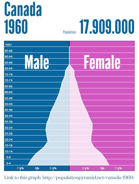
Population Pyramids
Below are two population maps of Canada for the years 1960 and 2010. In the image to the left, Canada's population was almost 18 million and the birth rate was high in the country. Young children made up a majority of the population during the 1960's. Now moving forward 50 years you can see that the mast quantities of children from the 1960's are now in their 50's, which still lies as the majority of the population. The birth rate is now lower and families are not having as many children, but the population is still increasing to over 34 million. The population of Canada over the 50 year span can be analyzed using these two population pyramids.
|

|
